Disaster Peak Tour


Are you up for an adventure? This tour is long and tough, and it traverses a section of the Sierra Crest that few people ski. There's a lot of varied terrain, and though this route can be done with only moderate technical challenges, it is a tough tour. We finally skied it in May 1999; parts of it went surprisingly smoothly, while a couple of sections went slowly. Overall, it was a rewarding, unique tour.

  Stanislaus Peak
Stanislaus Peak
The best approach to timing this tour is to wait until just after Sonora Pass Road (108) and Ebbetts Pass Road (4) are open, usually mid-May. It can also be done a few weeks earlier than that, once 108 is cleared up to within about 3 miles of the pass (11 miles west of 395) on its eastern side, by which time the east side of Hwy 4 should also be cleared up to around Silver Creek (7 miles west of 89). (For the most accurate information about exactly where these roads are closed, call the local Caltrans maintenance stations: 530-694-2241 for Hwy 4, 760-932-7261 for Hwy 108.) Or I suppose you could do the tour much earlier and add even more road walking miles. If you do the tour much later than mid-May, you're likely to start losing snow coverage. The tour's average elevation is just over 9000'. Parking is available at both ends.

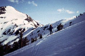
From Sonora Pass, drive or ski alongside the road northwest for about a mile, before heading due north. Head over the ridge at an elevation of about 10200' to 10400', and contour along the west side of the Sierra Crest, to the south of Stanislaus Peak. Then continue to contour around Stan's west side, as it becomes a somewhat steep traverse around Stan's north side. Once on the east side of the crest, ski the bowl (above photo) down to the pass. Then follow the crest northward around the east side of Peak 10379'; this is best done by gaining about 100' or so towards the peak, and then doing a sort of steep traverse across the peak's east slopes.

Continue to traverse to a NE-facing gulley. Descend that a few hundred feet, and continue to traverse. There are some good campsite possibilities around here, with outstanding views of this canyon of the upper East Fork Carson.

  Nobel Canyon
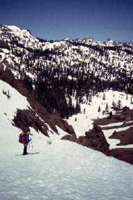
Looking down Nobel Canyon
Next, continue northward near and along the crest for a few miles. This involves some descending, some traversing, and a lot of rather convoluted tree-covered terrain. I won't try to describe the detailed route through here, except to say that you should generally stay east of the crest until you start to ascend the south shoulder of Boulder Peak. Then, turn westward to the south of Boulder Peak, doing a mild descent, and then ski uphill towards Disaster Peak. From Disaster's east side, head northwest to the north side of Disaster Peak, and continue to follow the Sierra Crest up the summit ridge towards the top of Arnot Peak.

Arnot Peak is named for an 19th century Alpine County superior court judge. And I'll bet he was mean too. Arnot's summit ridge is steeply corniced to the north and strewn with steep volcanic rubble to the south, so once you get to the summit ridge, you'll want to drop back down a few hundred feet to the south and traverse around the summit. Then climb back to about 9800' just west of Arnot and ski down the very fine north-facing bowl to the west of the summit. We took Camp 2 at the base of this run.

There are three options on the third day, so choose your poison:

Note that this tour has an unusual amount of relatively level and rolling terrain for a Sierra crest tour, so waxless patterned skis are highly recommended. Also, I can tell you that you'll need to be really on-the-ball with map and compass, and good at matching minor terrain features with them contour lines. My altimeter came in handy too. Enjoy!


 Previous Tour  Ski Tour Index  Next Tour

General info and disclaimer about backcountry skiing

Go to BobSkiing.com Home Page